Update Our ticketing, donations, and membership sales portal is down for scheduled maintenance on the afternoon of 4/11.
1942
GUSN-197264
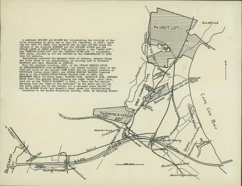
A map of Cape Cod showing ancient and modern details, by Channing Howard, presented to the Bourne Historical Society in 1942. The map provides details of old Cape Cod landmarks and settlements. The map includes three paragraphs of text. The first beigns: "A combined ANCIENT and MODERN MAP illustrating the vicinity of the first settlement by white men on Cape Cod (Sandwich, in 1637), showing the CAPE COD CANAL from Buzzards Bay to Cape Cod Bay along the valleys of the original MONUMENT and the SCUSSET RIVERS and the INDIAN LANDS at GREAT HERRING POND and vicinity..."
colonies
historic sites
historical maps
DigitalID 002105
AccessID 4071
Other identifier HNEDID-002105
1 map
MS028
Nina Heald Webber Cape Cod Canal collection
MS028.01.010.012
Cape Cod (Barnstable county, Massachusetts) [peninsula]
Cape Cod Canal (Massachusetts) [canal]
Buzzards Bay (Bourne, Barnstable county, Massachusetts) [neighborhood]
Howard, Channing (Cartographer)
historical maps
Bourne Historical Society
Wampanoag Indians
Item
Historic New England is committed to implementing reparative language description for existing collections and creating respectful and inclusive language description for new collections. If you encounter language in Historic England's Collections Access Portal that is harmful or offensive, or you find materials that would benefit from a content warning, please contact [email protected].
Sign up to our newsletter for our latest news and events